
Daniel Boone escorting settlers through the Cumberland Gap
In colonial Virginia and Carolina the most important travel ways were the main north-to-south trail commonly known as the Fall Line Road and Appalachian Trail. Early roads like this one were made by chopping out underbrush and small trees in a swath only ten to thirty feet wide. The axe men had to leave the largest trees standing, even in the middle of the road. They bridged small streams with logs and crossed rivers by fords or ferries. For the most part these were walking paths for pack horses and small wagons or carts.
Braddock Road, a military road, was built in 1755. It was constructed by troops of Virginia militia and British regulars as part of an expedition to conquer the Ohio Country from the French. It was the first improved road to cross the barrier of the many ridge lines of the Appalachian Mountains.
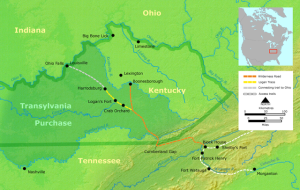
Map showing Cumberland Gap in relation to the Wilderness Road route from Virginia to Kentucky
The Wilderness Road about the year 1775 was cut through the Cumberland Gap of Virginia by Daniel Boone and his band of trailblazers across 200 miles of wilderness. It was steep and rough and could be traversed only on foot or horseback. Despite adverse conditions, thousands of people used it. The early pioneers lashed huge baskets and bundles of clothing, bed furnishings, and household articles on pack horses. Children perched on top, or rode in front and behind their mothers and relatives. The older boys and men usually had to trudge along on foot.
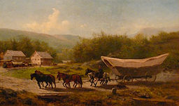
Painting depicting a Conestoga wagon. Note the severe angles at either end and the curved center, characteristics of the large Conestoga compared to other varieties of covered wagon.
In the mid-to-late 1700s the Conestoga wagon became a common vehicle on the trails of Pennsylvania. It grew larger as the road got wider and longer and was usually drawn by five or six draft horses. Its floor curved upward to prevent the contents of the wagon from tipping or shifting and could carry up to 12,000 pounds of cargo. The frame was made of wood, and the wheels were often iron-rimmed for greater durability. The cracks in the body of the wagon were stuffed with tar to protect them from leaking while crossing rivers. Water barrels were built on the side of the wagon as well as toolboxes for the tools needed for repair of the wagon. There was a feed box for horses on the back of the wagon. Before the Conestoga there were more primitive wagons and two-wheeled carts.
The National Road from Pennsylvania through Ohio was originally called the Cumberland Road early in the 1800s. It was the first road with a hard surface of compacted gravel called macadam, and it was referred to as the National Road because of its federal funding. Eventually it extended to Indiana and continued to Vandalia, Illinois. In 1926 it became part of US Route 40.
Trains reached across the Cumberland River from Baltimore by 1842, and by 1870 the Pittsburgh, Fort Wayne and Chicago Railway was a major part of the Pennsylvania Railroad system. It extended west from Pittsburgh, Pennsylvania via Fort Wayne, Indiana to Chicago, Illinois As the railroads expanded many westward bound seekers could ride steam powered trains, a vast advancement over horses and wagons. In fact train travel almost replaced the National Road until the advent of the automobile.